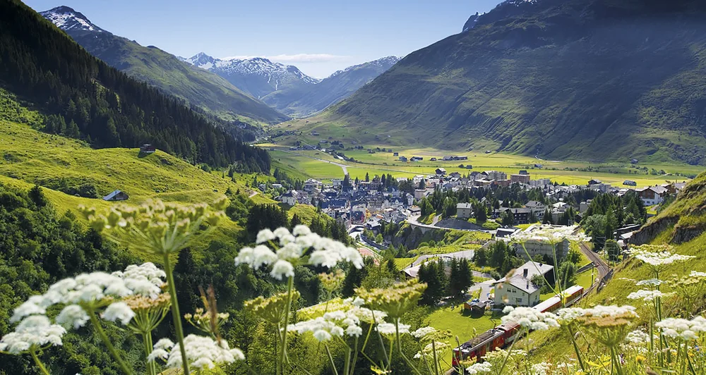
Andermatt
A garrison village at the junction of four passes, transformed by an Egyptian developer, and the place where the Gotthard route actually crosses.
Andermatt sits at 1,440 m in the Urseren valley, at the point where four Alpine passes meet: the Gotthard south to Ticino, the Furka west to the Valais, the Oberalp east to Graubünden, and the Susten over to the Bernese Oberland.
That junction is the whole story of the place. Whoever controlled it controlled the shortest route from northern Europe to Italy, and Switzerland kept an army garrison here for most of the twentieth century, with the mountains around it hollowed out into fortifications.
The Schöllenen gorge and the Devil’s Bridge
The reason the Gotthard route exists at all.
North of Andermatt the Reuss runs through the Schöllenen, a granite gorge so sheer that for centuries it blocked the route entirely. Around 1220 someone worked out how to bridge it, and the pass opened — an event that changed the trade of Europe and, not incidentally, led to the founding of the Swiss Confederation, since the valleys controlling the new route wanted to keep the profits.
The legend attached to it is the standard one: the locals could not build the bridge, the Devil offered to, and asked for the soul of the first to cross. They sent a goat.
The present Teufelsbrücke is the third on the site, and the two earlier ones are visible below it. Beside it, cut into the rock face, is a twelve-metre cross and an inscription in Russian — the Suvorov monument, marking the battle in 1799 when Russian troops under Suvorov fought their way through the gorge against the French. The land it stands on was given to Russia in 1898 and remains Russian property.
Suvorov’s crossing
Before the bridge, there was the Urnerloch: a tunnel driven through the rock between Andermatt and the Reuss, only two metres wide and 67 metres long, and at the time the only way through. The French held it, with a cannon loaded with grapeshot trained on the entrance. Suvorov sent around 300 men over the mountain above it instead, iron spikes strapped to their boots for grip on the ice, to take the position from behind — the same tactic that broke the French at the bridge itself. A waterfall drops from the gorge just below the tunnel’s mouth; the Devil’s Bridge crossed the ravine a short way downstream of it.
The monument by the bridge was commissioned and paid for by Prince Golitsyn, built over three years under the Swiss architect Zschokke, and unveiled in 1898. The ground around the cross, some 495 square metres, belongs to Russia, which is why a Russian flag flies over it. It was restored a century later, in 1998, with funding from the local authorities, the canton of Uri and a Russian sponsor.
A second Suvorov monument stands at Gotthard Passhöhe, at the top of the pass, a postbus ride from Andermatt. Unlike the cross at the bridge, it shows the man rather than the myth: an exhausted seventy-year-old general, his horse led by a local guide, with a plaque in Russian and Italian below. Trails from the pass lead out past mountain lakes and rock shaped by glaciers.
The passes
In summer, all four are open and the post buses run over them. This is one of the great bus rides in Europe, and it costs an ordinary fare.
Furka is the one with the glacier: the road passes the Rhône glacier and its ice grotto, and the pass appeared in Goldfinger. The Furka steam railway, restored by volunteers, runs over the old line in summer.
Oberalp carries the Glacier Express over its 2,033 m summit, and the source of the Rhine — Lai da Tuma — is a two-hour walk from the top.
Susten is the best-engineered of them, and Gotthard’s old cobbled road over the Tremola, with its twenty-four hairpins, still exists beside the modern one.
Most close from about October to May, when the car-carrying rail shuttles take over — see driving in Switzerland.
The passes climb to similar heights: Gotthard tops out at 2,108 m, Furka at 2,431 m and Susten at 2,224 m, all within a few hundred metres of the Oberalp’s 2,033 m.
Beyond the ordinary postbus timetable, three named routes run through Andermatt for anyone treating the journey itself as the point. One crosses the Gotthard and the Nufenen pass into the Obergoms; another goes over the Furka and the Grimsel to Meiringen and on over the Grosse Scheidegg to Grindelwald; the Wilhelm Tell Express combines a boat across Lake Lucerne from Lucerne with a train over the Gotthard into Ticino. All three run on ordinary Swiss Pass and day-ticket fares, on top of which a seat reservation is usually required.
Two earlier attempts at a resort
Andermatt tried this before. In the closing decades of the nineteenth century the village built a run of grand hotels below the Gemsstock — the Bellevue, the Grand Hôtel Danioth, the Gotthard — and briefly ranked among the fashionable resorts of Europe; Switzerland’s second-ever cable lift opened here in 1937.
The Second World War ended that. Tourism collapsed, the hotels went into disrepair, and by the time the village had the money to fix them, other resorts had taken their place. It stayed a quiet garrison town for the rest of the century.
The new Andermatt
The village was a garrison town in decline until the Egyptian developer Samih Sawiris began building here in 2009: a new quarter of hotels and apartments, a golf course, and a merged ski area linking Andermatt with Sedrun and Disentis over the Oberalp.
The result is a village with two distinct halves, and opinions locally are divided. The skiing, particularly the Gemsstock with its long off-piste descents, was always good and is now better served.
The ski area covers four sectors — Gemsstock, Nätschen, Winterhorn and Realp — running from around 1,450 m up to the Gemsstock’s 2,963 m, with roughly 74 km of piste, mostly blue and red with a handful of black runs; the longest single run drops 751 vertical metres. The season runs from mid-December to the end of April.
The Suvorov house
The largest chalet on Andermatt’s main street, built in 1786, is where Suvorov is said to have spent the night before the battle, and it has carried his name locally ever since. It is now a small local-history museum, the Talmuseum, with period rooms and displays on the history and traditional building style of the Urseren valley.
Getting there
- By train — Zurich about two hours via Göschenen; Lucerne about two hours. The line from Göschenen up the Schöllenen is a rack railway and takes fifteen minutes.
- The Gotthard Base Tunnel passes underneath without stopping — trains to Ticino no longer come through Andermatt at all, which is why the village is quieter than it was.
- The Glacier Express stops here, halfway between St. Moritz and Zermatt.
When to go
July to September for the passes, the walking and the steam railway — this is the only window when all four roads are open. December to April for skiing.
May, June and October are the awkward months: the passes are shut, the snow is unreliable, and much of the village closes.
Early autumn brings two fixed dates: a grape-harvest festival in September, and a memorial service at the Suvorov monument on 25 September, attended by cadets from a Russian military academy named after him.
Nearby
Other places on this site within easy reach, as the crow flies:
- Engelberg and Titlis — 25 km
- Meiringen and the Reichenbach Falls — 33 km
- Schwyz — 43 km
- Brienz and Ballenberg — 45 km
- Wengen — 52 km
- Lauterbrunnen — 53 km
This page in Russian: Андерматт (Andermatt)
Where to park in Andermatt
| Car park | Spaces | Fee | From centre |
|---|---|---|---|
| Gemsstockbahn | — | paidmax 1 d | 310 m |
| Gotthard Camping Andermatt | — | paid | 360 m |
| Rossstall | — | paid | 580 m |
| Andermatt Reuss underground | 240 | paid | 710 m |
| Bäz | — | paid | 820 m |
Data © OpenStreetMap contributors, ODbL licence, snapshot of 22 August 2026. The map is drawn by volunteers: the list is not complete, and a dash means “not recorded” — not “free” and not “no spaces”. This is not an official parking directory: when you get there, read the signs and the machine at the entrance.
Weather in Andermatt month by month
| Month | Day | Night | Rainfall |
|---|---|---|---|
| January | -1° | -9° | 74 mm |
| February | -1° | -9° | 63 mm |
| March | +2° | -6° | 83 mm |
| April | +6° | -1° | 115 mm |
| May | +13° | +4° | 152 mm |
| June | +17° | +8° | 164 mm |
| July | +19° | +10° | 152 mm |
| August | +19° | +10° | 166 mm |
| September | +15° | +6° | 135 mm |
| October | +10° | +3° | 128 mm |
| November | +4° | -3° | 128 mm |
| December | 0° | -8° | 87 mm |
Averages for 1991–2020, computed from NASA POWER daily data and corrected for the elevation of the place (1443 m). Day and night are the average daily high and low, not records; rainfall is approximate. Current conditions from the Norwegian Meteorological Institute, CC BY 4.0.
Updated: