Bellinzona
The best medieval fortification in the Alps, UNESCO-listed, and skipped by almost everyone heading for Italy in a tunnel underneath it.
Bellinzona guards the point where the routes over the Gotthard, San Bernardino, Nufenen and Lukmanier passes all funnel into one valley. Whoever held it controlled the way from Germany into Italy, and from the thirteenth century the dukes of Milan spent a great deal of money making sure they held it.
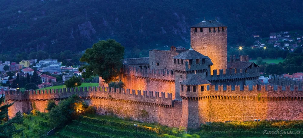
The result is three castles and a wall across the valley floor, the most complete example of late-medieval defensive architecture in the Alps, and a UNESCO World Heritage site.
Almost nobody stops. The trains to Lugano and Milan run straight through, and the castles are visible from the window for about fifteen seconds.
History
For centuries the town was fought over by the Milanese aristocracy and the Swiss confederates pressing down from the passes above it. It passed firmly into Swiss hands early in the sixteenth century, and the treaty that followed fixed the border where it still runs today.
The three castles
They are connected by footpaths and can be done in half a day.
Castelgrande is the oldest and the largest, on the rock in the middle of town — occupied since the neolithic, fortified by the Romans, and rebuilt by the Sforza. A lift inside the rock takes you up from the street, which is the least expected thing in the town. Two towers, a long courtyard, and the view down onto the roofs.
Archaeological finds put the first fortress on this rock in the fourth century, with defences documented here by the sixth. The building was extended in stages, took roughly its current form from the thirteenth century, was enlarged again in the 1470s and 80s, and was restored twice more, in the seventeenth and nineteenth centuries. Its two towers, the White Tower and the Black Tower, date from the thirteenth and fourteenth centuries and stand 27 and 28 metres respectively. The museum inside holds finds from the site alongside a set of painted fifteenth-century ceiling panels rescued from a Bellinzona townhouse, including a comic “world upside-down” series — among other reversals, an ox ploughing a field behind a man.
Montebello, higher and to the east, is the picture: concentric walls, a dry moat and a keep, reached on foot in fifteen minutes from Castelgrande along the ridge.
The hill gave the castle its name and stands roughly 90 metres above Castelgrande; a small museum inside covers the town’s history. The oldest part of the building dates from the thirteenth and fourteenth centuries, though it was rebuilt more than once afterwards as weapons and tactics changed. The old town’s own walls started here and ran on to join those on the Castelgrande hill; stretches of both still stand, and a further section came to light when houses on Piazza del Sole were later cleared.
Sasso Corbaro, higher again and alone on its hill, was built in six months in 1479 after the Swiss beat the Milanese at Giornico and Milan panicked. It is the steepest walk and has the widest view.
It stands about 3.5 kilometres uphill from Montebello and 230 metres above the town, high enough to command the whole Ticino valley below. The design — a stark square courtyard behind a wall up to 4.7 metres thick where it meets the keep — was the work of the Florentine military engineer Benedetto Ferrini, who died of plague shortly before the castle was finished. It has carried several names since: Unterwalden Castle when the Swiss first held the valley, Santa Barbara from 1818, and Sasso Corbaro, or Castello di Cima, today.
The Murata
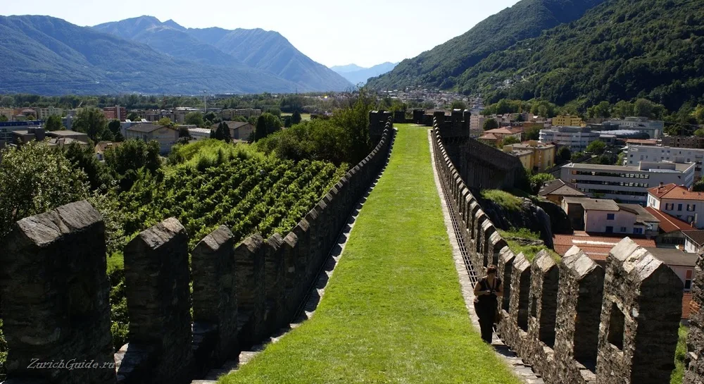
The wall that runs across the valley floor from Castelgrande — the Murata — is what makes the site remarkable. It was not defending a town: it was closing a valley, from one mountainside to the other, to stop an army passing.
Long stretches survive, with a walkway on top and vineyards beside it. Standing on it makes the geography of the whole Alpine crossing suddenly obvious.
Churches
The Collegiata dei Santi Pietro e Stefano, the town’s largest church, was built in the sixteenth century south of the station at the foot of the Castelgrande hill. It is Renaissance with Baroque additions, and richly frescoed inside.
San Rocco, on Piazza dell’Indipendenza, has a large fresco of St Christopher and a smaller one of the Virgin and Child.
San Biagio, a fourteenth-century church about 500 metres south of the same square, keeps its old frescoes unrestored.
West of the station, Santa Maria delle Grazie is a fifteenth-century church with a large fresco of the Crucifixion covering one wall, damaged by a fire in 1997.
The town
Italian-speaking, arcaded, and rather unaffected by tourism. Piazza Collegiata and the streets around it fill on Saturday morning with one of the best markets in Ticino — cheese, chestnuts, salami, and produce from the valleys.
A former Augustinian monastery now houses the cantonal government.
The Villa dei Cedri holds the art museum in a park of cedars and vines.
Its collection is mostly work by local painters and by artists from northern Italy, from the nineteenth and twentieth centuries.
Finding your way
From the station, the old town is about five minutes on foot: cross the square outside and take the street on the left, and Castelgrande appears on its hill almost at once. The other two castles show on the hill opposite; the main church sits below them, with the town hall tower to the right. That is, roughly, the whole old town, which continues to Piazza dell’Indipendenza and the church of San Rocco; San Biagio and Santa Maria delle Grazie are a further ten minutes on from there.
Around Bellinzona
The town makes a reasonable base for day trips across Ticino: to Locarno, with onward buses to Ascona, to Lugano, up to the viewpoints of Monte Bré, Monte Tamaro or Monte San Salvatore, to the miniature-Switzerland park at Melide, or to the outlet shopping at Mendrisio. Both Lake Lugano and Lake Maggiore are within reach for a cruise.
Getting there
- By train — Lugano 25 minutes, Zurich about two hours through the Gotthard Base Tunnel, Lucerne about two hours on the old line.
- Stopping here costs an hour or two off a journey south and is the best-value stop on that line.
- On foot — Castelgrande is five minutes from the station; the other two are a climb.
- There are also direct trains from Basel and Bern, each roughly three and a half hours, and from Milan, under two hours, via Chiasso and Lugano.
- Regional trains connect Bellinzona to Locarno (via Tenero or Cadenazzo) and to Chiasso (via Lugano and Mendrisio).
- The older route to Zurich and Lucerne runs via Airolo, over the historic Gotthard pass villages, then Flüelen, Brunnen and Schwyz — slower than the base tunnel, but the way most travellers saw this valley before it opened.
- There is no direct train from French-speaking Switzerland; expect several changes and at least four hours each way.
When to go
Spring and autumn. Ticino in July and August is hot and humid, and the castle walks are unshaded.
The carnival — Rabadan — in February is one of the largest in Switzerland, and the castles are floodlit through the year.
Rabadan has been running for more than 150 years.
More on the country’s fortifications in castles in Switzerland.
Nearby
Other places on this site within easy reach, as the crow flies:
- Andermatt — 59 km
- Sils Maria — 63 km
- Laax and Flims — 71 km
- St. Moritz — 71 km
- Pontresina — 75 km
- Brig — 81 km
This page in Russian: Беллинцона (Bellinzona)
Where to park in Bellinzona
| Car park | Spaces | Fee | From centre |
|---|---|---|---|
| Piazza Governo | — | paidmax 2 h | 110 m |
| Underground car park | — | paid | 280 m |
| Parcheggio Tatti | — | paid | 500 m |
| Parcheggio Ex Stallone | — | — | 520 m |
| Piazzale Stadio | — | paid | 780 m |
| Ospedale San Giovanni multi-storey | 250 | paid | 1.0 km |
Data © OpenStreetMap contributors, ODbL licence, snapshot of 22 August 2026. The map is drawn by volunteers: the list is not complete, and a dash means “not recorded” — not “free” and not “no spaces”. This is not an official parking directory: when you get there, read the signs and the machine at the entrance.
Weather in Bellinzona month by month
| Month | Day | Night | Rainfall |
|---|---|---|---|
| January | +7° | -3° | 72 mm |
| February | +9° | -2° | 62 mm |
| March | +14° | +2° | 87 mm |
| April | +18° | +6° | 158 mm |
| May | +22° | +10° | 197 mm |
| June | +26° | +14° | 178 mm |
| July | +28° | +15° | 156 mm |
| August | +27° | +15° | 194 mm |
| September | +22° | +11° | 196 mm |
| October | +17° | +7° | 202 mm |
| November | +11° | +2° | 214 mm |
| December | +7° | -3° | 90 mm |
Normals for 1991–2020 from MeteoSwiss, station Magadino / Cadenazzo, open data, version of 29 July 2026. Day and night are the average daily high and low, not records; rainfall is approximate. Current conditions from the Norwegian Meteorological Institute, CC BY 4.0.
Updated: