Graubünden
A fifth of Switzerland, 150 valleys, three languages, two UNESCO railways and the only national park in the country.
Graubünden is the largest canton in Switzerland — about a fifth of the country — and the emptiest, with around 200,000 people spread across some 150 valleys.
It is the only canton with three official languages: German, Italian and Romansh, the fourth national language, spoken here and essentially nowhere else. It also has the only national park in Switzerland and two UNESCO-listed railways.
The name comes from the Grey Leagues, three alliances of valley communities that governed themselves from the fourteenth century — which is why the canton has always felt like a federation of valleys rather than a unit.
The valleys
The Engadin — the long high valley of the Inn, sunny and dry, running north-east to south-west. Upper Engadin has St. Moritz, Pontresina, Sils Maria and the lakes. Lower Engadin has Scuol, Tarasp and the sgraffito villages, and is where Romansh is strongest.
Prättigau and Davos — Davos and Klosters, and the Vereina tunnel through to the Engadin.
Schanfigg — Arosa, at the end of the railway that leaves Chur through the streets.
Surselva — the upper Rhine, with Laax and Flims and the Rhine gorge.
Valposchiavo and Val Bregaglia — south of the watershed, Italian-speaking, reached over the Bernina and Maloja passes.
The railways
The reason a great many people come.
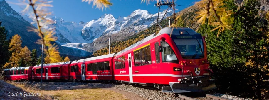
The Albula line from Chur to St. Moritz — spiral tunnels stacked inside the mountain, the Landwasser viaduct curving into a cliff face, and UNESCO World Heritage status shared with the Bernina.
The Bernina line — the highest transalpine crossing without a rack, from glaciers to palm trees in four hours.
The Glacier Express runs the Albula section on its way to Zermatt.
All three are ordinary public track. The regional trains cover the same routes at a fraction of the price.
The National Park
Founded in 1914, the oldest in the Alps and the strictest: nothing managed, nothing planted, no dogs, no camping, and you must stay on the marked paths.
Red deer, ibex, chamois, marmots and reintroduced bearded vultures. Visitor centre at Zernez, open roughly June to November.
Romansh
Around 40,000 speakers, most of them here, in five written dialects plus a unified standard. It descends directly from the Latin of the Roman province.
Road signs, schools and local newspapers use it in the Engadin and Surselva, and it is the reason for the place names that look like nothing else in Europe. See languages.
Getting there
- By train — Zurich to Chur an hour and a quarter, and Chur is the gateway: every narrow-gauge line into the canton starts there.
- The Vereina tunnel carries cars under the mountains from Klosters to the Engadin all year, when the passes are shut.
When to go
July to September for walking and the national park. Late September and early October for the larches, which is the canton’s best week.
December to April for skiing — St. Moritz, Davos-Klosters, Arosa-Lenzerheide and Laax are all here.
Weather in Graubünden month by month
| Month | Day | Night | Rainfall |
|---|---|---|---|
| January | +5° | -2° | 54 mm |
| February | +7° | -2° | 40 mm |
| March | +12° | +2° | 53 mm |
| April | +16° | +5° | 50 mm |
| May | +20° | +9° | 70 mm |
| June | +23° | +12° | 93 mm |
| July | +25° | +14° | 101 mm |
| August | +25° | +14° | 119 mm |
| September | +20° | +10° | 77 mm |
| October | +16° | +7° | 67 mm |
| November | +10° | +2° | 69 mm |
| December | +6° | -1° | 58 mm |
Normals for 1991–2020 from MeteoSwiss, station Chur, open data, version of 29 July 2026. Day and night are the average daily high and low, not records; rainfall is approximate. Current conditions from the Norwegian Meteorological Institute, CC BY 4.0.
Updated: