Schaffhausen
A painted old town on the German side of the Rhine, under a round fortress where the keeper still rings the bell at nine.
Schaffhausen is the capital of the northernmost canton, on the right bank of the Rhine — the German side — and almost entirely surrounded by Germany. The town grew up because boats had to be unloaded here: the Rhine Falls a few kilometres downstream stop navigation dead, and everything had to go overland.
That toll traffic paid for the old town, which survives in unusual completeness.
The Munot
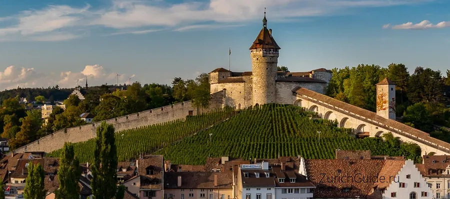
The fortress above the town is circular, which is rare, and it was built between 1564 and 1589 to a design derived from Albrecht Dürer’s treatise on fortification. Inside is a vaulted casemate with a spiral ramp wide enough to ride a horse up.
It has never been besieged. Its slope is planted with vines, deer live in the moat, and the keeper still lives in the tower and rings the bell at nine every evening — a duty that once signalled the closing of the town gates and is now simply continued.
Entry is free, and the parapet gives the whole town and the river.
The oriels
Schaffhausen’s speciality is the Erker, the projecting bay window — there are around 170 of them in the old town, more per street than anywhere else in the country. They were a merchant’s advertisement: a way to see up and down the street, and to show what you could afford.
The most decorated house is Haus zum Ritter on Vordergasse, whose entire facade was frescoed in the 1570s with scenes of Roman virtue. What you see now is a copy; the surviving originals are in the museum.
Museum zu Allerheiligen, in the former Benedictine abbey, holds those frescoes along with the town’s history, and the abbey’s Romanesque cloister is the quiet corner of Schaffhausen.
The Rhine Falls
Half an hour on foot along the river, or five minutes by train: the largest waterfall in Europe by volume, 150 m wide, with a rock in the middle you can climb by boat.
It has its own page — see the Rhine Falls — and it is the reason most people come this way. Combining the two makes a full day out of Zurich.
Getting there
- By train — Zurich to Schaffhausen is about 40 minutes direct.
- By boat — in season, boats run up the Rhine from Schaffhausen to Stein am Rhein and on towards Lake Constance. This is the pleasant way to do it, and rail passes cover it.
- By car — remember that the road from Zurich crosses German territory in places; there is no border formality, but a hire car’s insurance should cover it.
Around
- The Rhine Falls — 30 minutes’ walk
- Stein am Rhein — 20 minutes by train or an hour and a half by boat, and the most decorated small town in Switzerland; see the ten most beautiful towns
- Germany — Konstanz and Lake Constance are half an hour east
- Winterthur — on the way back to Zurich, with a very good art museum
When to go
Spring to autumn, when the boats run and the falls are full. The old town works in any weather — the oriels are best in low winter sun, which throws them into relief.
The Munot Ball in September and the Christmas market in December are the two dates the town organises itself around.
Where to park in Schaffhausen
| Car park | Spaces | Fee | From centre |
|---|---|---|---|
| Parkhaus Herrenacker underground | 250 | paid | 110 m |
| Kirchhofplatz | — | paid | 150 m |
| Walther-Bringolf-Platz | — | free | 180 m |
| Parkhaus Stricki (P3) underground | — | paid | 310 m |
| Landhaus | 22 | paid | 340 m |
| City Parking multi-storey | — | — | 380 m |
| Parkplatz Munothalle | 112 | paid | 570 m |
| Parkplatz Mühlentalstrasse | — | paid | 630 m |
11 more are mapped nearby — see them on OpenStreetMap.
Data © OpenStreetMap contributors, ODbL licence, snapshot of 22 August 2026. The map is drawn by volunteers: the list is not complete, and a dash means “not recorded” — not “free” and not “no spaces”. This is not an official parking directory: when you get there, read the signs and the machine at the entrance.
Weather in Schaffhausen month by month
| Month | Day | Night | Rainfall |
|---|---|---|---|
| January | +4° | -2° | 72 mm |
| February | +6° | -1° | 60 mm |
| March | +11° | +2° | 64 mm |
| April | +16° | +5° | 68 mm |
| May | +20° | +9° | 100 mm |
| June | +23° | +13° | 95 mm |
| July | +25° | +14° | 103 mm |
| August | +25° | +14° | 95 mm |
| September | +20° | +10° | 72 mm |
| October | +14° | +7° | 77 mm |
| November | +8° | +2° | 73 mm |
| December | +4° | -1° | 86 mm |
Normals for 1991–2020 from MeteoSwiss, station Schaffhausen, open data, version of 29 July 2026. Day and night are the average daily high and low, not records; rainfall is approximate. Current conditions from the Norwegian Meteorological Institute, CC BY 4.0.
Updated: