Thun
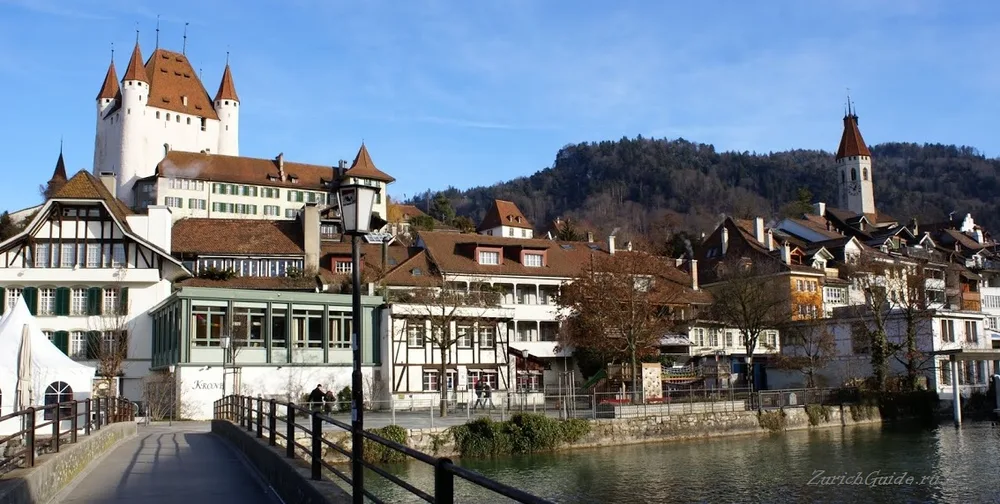
A medieval town on its own lake with a picture-book castle above it, and a main street where the pavement runs along the shop roofs.
Thun sits where the Aare leaves its lake, twenty minutes from Bern, with the Bernese Alps filling the view south. It is the gateway to the Oberland and most people go straight through it on the way to Interlaken, which is a mistake.
The panorama is the reason. Behind the lake stand the three famous ones — Mönch, Eiger and Jungfrau — and closer in, framing the view from either side, the pyramid of the Niesen (2,362 m) and the flat top of the Stockhorn (2,190 m). Both have their own lifts, and the Niesen has a funicular with a staircase beside it of 11,674 steps, opened to runners once a year.
Thun is also one of the ten largest towns in the country and has a military history that is not advertised. It is a garrison town, and after the Second World War the plan in the event of an invasion was for the population south of here to gather at Thun and disperse into the mountains. Local lore has it that a full military hospital was built inside the Niesen, kept in working order and never once used — one of an unknown number of such things in these mountains.
The castle
Schloss Thun is the picture-book one: a square twelfth-century keep with four round corner towers and a red roof, built by the Zähringen dukes, standing over the town on a small hill.
It is now a museum covering the town’s history, and the climb into the towers gives the lake, the town and the Alps. The stair up to it from the market square is a covered wooden one, which is a pleasure in itself.
The street on two levels
Thun’s real oddity, and the thing you will not see anywhere else.
The Obere Hauptgasse is built with shops at street level and a second row of shops behind and above them — and the pavement for the upper row runs along the roofs of the lower. So the main street has two footpaths at different heights, one of them on top of the shops, with flower boxes and café tables on it.
It was a medieval solution to a steep, narrow site, and it survives intact.
The lake
Lake Thun is the larger of the two Oberland lakes, and the boats from the pier by the station are public transport covered by rail passes. Several are historic paddle steamers.
Along the shore: Schloss Oberhofen, with a tower standing in the water and a garden running down to it, and Schloss Spiez on its own peninsula among vineyards. Both are museums, both are reachable by boat, and either makes an afternoon.
The Beatus caves on the northern shore run a kilometre into the mountain past underground waterfalls, with a hermit’s cave at the entrance.
Schadau
Where the river leaves the lake stands the Schadau park, with a nineteenth-century château and the best single view in Thun — the water, the town, and the Eiger, Mönch and Jungfrau lined up behind.
In the park is the Thun Panorama, the oldest surviving circular panorama painting in the world: a 38-metre canvas of the town painted by Marquard Wocher between 1809 and 1814, shown in a purpose-built rotunda. It predates every other panorama still standing.
Getting there
- By train — Bern 20 minutes, Interlaken 25 minutes, Zurich about an hour and a half.
- By boat — from Interlaken West along the lake, about two hours, and much the better arrival.
- On foot — everything above except the lake castles is within fifteen minutes of the station.
- By bike, free — Thun Rollt lends bicycles from May to October for nothing: leave an identity document and a deposit of 20 francs and bring the bike back the same day. The flat shore road towards Oberhofen is the obvious ride.
When to go
Summer, when the boats run at full frequency and the town spends its evenings on the river. The Aare through Thun is a swimming river like the one in Bern, with the same warnings about current and exit points.
December brings a good Christmas market around the castle hill.
Thun is on the list of the ten most beautiful towns, at number four.
Where to park in Thun
| Car park | Spaces | Fee | From centre |
|---|---|---|---|
| City West multi-storey | — | paid | 150 m |
| Aarezentrum multi-storey | — | paid | 160 m |
| Bärenplatz | — | — | 210 m |
| Schlossberg Parking multi-storey | 300 | paid | 250 m |
| Rex-Max underground | 120 | paid | 360 m |
| Burgzentrum multi-storey | — | paid | 370 m |
| Manor underground | — | paid | 370 m |
| City Nord multi-storey | — | paid | 390 m |
10 more are mapped nearby — see them on OpenStreetMap.
Data © OpenStreetMap contributors, ODbL licence, snapshot of 22 August 2026. The map is drawn by volunteers: the list is not complete, and a dash means “not recorded” — not “free” and not “no spaces”. This is not an official parking directory: when you get there, read the signs and the machine at the entrance.
Weather in Thun month by month
| Month | Day | Night | Rainfall |
|---|---|---|---|
| January | +4° | -3° | 73 mm |
| February | +5° | -2° | 66 mm |
| March | +10° | +1° | 75 mm |
| April | +14° | +4° | 84 mm |
| May | +18° | +8° | 125 mm |
| June | +21° | +12° | 117 mm |
| July | +23° | +14° | 117 mm |
| August | +24° | +14° | 116 mm |
| September | +20° | +10° | 93 mm |
| October | +15° | +7° | 94 mm |
| November | +9° | +2° | 86 mm |
| December | +5° | -2° | 91 mm |
Averages for 1991–2020, computed from NASA POWER daily data and corrected for the elevation of the place (562 m). Day and night are the average daily high and low, not records; rainfall is approximate. Current conditions from the Norwegian Meteorological Institute, CC BY 4.0.
Updated: